No part of New Brunswick likely to escape Lee’s wrath
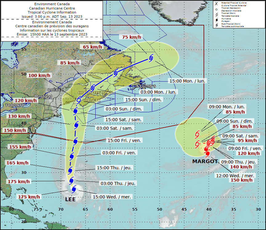
With Hurricane Lee threatening wind gusts up to 100 km/hr and rainfall potentially to exceed more than 100 mm across New Brunswick, including the Upper St. John River Valley, on Saturday, Sept. 16, EMO officials urge everyone to be prepared.
While the strength of Hurricane Lee is dropping as it approaches landfall somewhere between Grand Manan, N.B. and Shelburne, N.S, Saturday morning, it remains a threatening storm, said Kyle Leavitt, the New Brunswick Emergency Measures Organization director.
“The storm is getting weaker, but it is growing in size,” he said. “Today and Friday are the time to prepare for this storm. There is and will be a lot of information to help you make good decisions, but perhaps the easiest and best thing you can do is exercise common sense. Stay informed and stay safe.”
Environment Canada and Climate Change meteorologists forecast Hurricane Lee’s landfall for Saturday morning, with hurricane warnings expected for Grand Manan and the Charlotte County coast in New Brunswick and southwestern Nova Scotia.
Currently, under a tropical storm watch, forecasters expect to issue a warning on Friday for Saint John County, Fundy National Park, and Moncton and Southeast New Brunswick.
Environment Canada warns the storm’s impact will deliver a heavy blow to the entire Maritime provinces.
Areas under the hurricane warning could experience wind gusts as high as 120 km/hr. Those under tropical storm warnings, including Saint John and Moncton, could face potential sustained winds of 60 km/hr, with gusts between 90 and 100 km/r.
Forecasters suggest residents of other parts of New Brunswick, including Woodstock and Carleton County, prepare for wind gusts of 80 km/hr or higher.
The remnants of Lee will also deliver flood-threatening rains across Woodstock, Carleton County, northwestern New Brunswick, well into Quebec.
“Rainfall totals in excess of 100 mm are possible, especially in areas to the left of the track,” said Environment Canada and Climate Change officials on their website.
New Brunswick Public Safety Minister Kris Austin, EMO officials and NB Power spokesman Trent Martin, executive director for transmission and distribution operations, said the province is preparing for potential electrical outages, road closures and other storm damage.
Martin said NB Power had already established an emergency operations centre and will stage its 600 personnel in critical areas across the province.
Austin noted the full foliage and the rain-soaked ground from the province’s wet summer and recent rain add to the concern about falling trees.
As they prepare for the worst and hope for the best, Austin said EMO and Public Safety officials will stay in communication with local government officials.
He said New Brunswickers can stay updated with the latest developments online at the NBEMO, Public Safety and Environment and Climate Change Canada websites and associated social media sites.
Woodstock Mayor Trina Jones said town residents can stay abreast of local efforts on the Town of Woodstock website.
Chief Operating Officer Andrew Garnett said town officials met on Wednesday to map out a response plan when needed.
“We had a meeting with police, fire and public works yesterday to ensure all departments are prepared and ready for anything that may arise,” he said. “All departments are continuing to monitor the storm and will through the weekend.”
Garnett said the town is working with the Red Cross to establish the AYR Motor Centre as a shelter if required, but the plan still needs to be implemented.
“If it gets to a point where these spots are needed, we will be informing the public of the next steps,” he said.
Hartland Fire Chief and council member Mike Walton said first responders, town staff and emergency measures officials will remain on alert until the storm threat passes.
He said the Hartland fire hall and community centres in Coldstream and Lakeville will serve as shelters and charging stations if required.
All officials stressed the importance of preparations before the storm hits.
All residents should secure their property.
— Bring in furniture and other items that the wind can toss around.
— Seal basement windows and doors.
— Trim and remove damaged trees and blankets
— Clear storm drains and gutters
— Ensure sump pumps are working
The Woodstock website storm stresses the importance of preparing an emergency kit, outlining what is needed. That includes
— 2 litres of water per person per day
— Non-perishable food
— Manual can opener
— Battery or cranked-power radio
— Prescription medications
— Specialty items. E.g., infant formula, pet food, etc.
— First aid kit
— Flashlight
— Candles, matches or a lighter
— Batteries
— Cash (ATMs may not be operational)
— Spare keys
— Copies of your emergency plan
— Copies of important papers like your driver’s license, birth certificate and insurance papers.


