‘This is a storm we haven’t seen in many, many years,’ says meteorologist

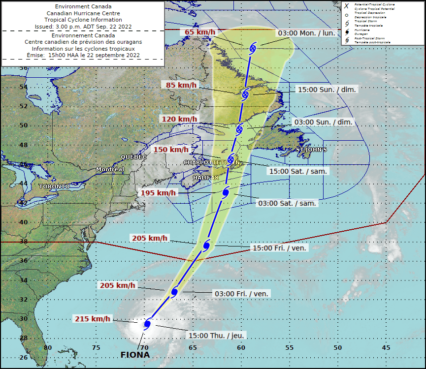
Hurricane Fiona heads to Atlantic Canada. (Environment Canada Image)
Northwestern N.B. ‘probably best off’ when Fiona slams Maritimes
‘This is a storm we haven’t seen in many, many years,’ says meteorologist
By Jim Dumville, Local Journalism Initiative Reporter
York, Carleton, Victoria and Madawaska counties will face potential wind gusts of 70 to 80 km/hr on Saturday, but they’ll likely escape the brunt of Hurricane Fiona’s wrath.
“Out of the Maritimes, you’re probably the best off,” said Environment Canada meteorologist Jill Maepea about the residents of northwestern New Brunswick.
She said P.E.I, Nova Scotia and eastern New Brunswick would feel the true force of Fiona on Saturday.
As the eye of the storm heads close to landfall in the early morning hours of Saturday, Sept. 24, current forecasts show it packing winds as high as 195 km/h. Winds could drop slightly to 150 km/h when it slams into Cape Breton as a post-tropical storm early Saturday afternoon.
Maepea said the latest forecast indicates Fiona will arrive in Nova Scotia waters Friday night, passing through eastern Nova Scotia and Cape Breton Saturday, and then reaching the Lower Quebec North Shore and Southeastern Labrador early Sunday.
The Environment Canada forecast indicates hurricane-force winds and significant rainfall to deliver major impacts on eastern Prince Edward Island, eastern Nova Scotia, western Newfoundland, eastern Quebec, and southeastern Labrador.
It also warns of high waves and storm surges in parts of Nova Scotia, the Gulf of St. Lawrence and western Newfoundland.
Maepea said eastern and northern New Brunswick and parts of the Gaspé are also at risk for high winds, heavy rain and potential storm surge along coastal areas.
She warned anyone on the storm’s track to prepare for a heavy hit.
“This is a storm we haven’t seen in many, many years,” Maepea said.
While Fiona will transition from a hurricane to a post-tropical storm as it hits the Atlantic Provinces, Maepea warns residents in its path not to let the designation fool them.
She explained the terms hurricane and post-tropical storm refer to a change in structure, not a reduction in wind velocity or rain levels.
Fiona will change from the familiar swirling hurricane pattern with the clear eye to a less-structured but still powerful storm as it collides with other weather patterns.
Maepea said Fiona is forecast to move beyond most of the Maritimes by Sunday. However, the forecasts for Sunday and the early part of next week includes more rain.
“Typical fall weather,” Maepea said.


